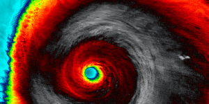
Hurricane Milton rapidly intensified on Monday, becoming a Category 5 storm and one of the most powerful hurricanes on record. According to the National Hurricane Center (NHC), Milton’s maximum sustained winds are near 180 miles per hour, classifying it as a “potentially catastrophic” hurricane.
With a barometric pressure dropping to 897 millibars, Milton ranks among the strongest storms in history in terms of both wind speed and pressure.
How Strong Can an Atlantic Hurricane Get?
A 1998 study by MIT climatologist Kerry Emanuel suggested that hurricanes in the Atlantic or Gulf of Mexico could reach wind speeds up to 190 miles per hour. While this is considered the upper limit, some experts believe climate change may push these limits even higher. There’s even been discussion about introducing a “Category 6” to the Saffir-Simpson scale.
Milton’s Winds Among the Strongest Ever
Although Milton’s wind speeds of 180 miles per hour are impressive, they aren’t the highest recorded in the Gulf of Mexico. Hurricane Allen still holds the record, with winds reaching 190 miles per hour as it passed through the Yucatan Channel in 1980. Allen caused widespread devastation and was responsible for 269 fatalities across the Caribbean.
How Does Its Barometric Pressure Compare?
While Milton’s pressure is extremely low at 897 millibars, it doesn’t beat the all-time Atlantic record. That distinction belongs to Hurricane Wilma, which dropped to 882 millibars in 2005. Although Wilma weakened before striking Florida as a Category 3 storm, it caused significant damage and 52 fatalities.
What to Expect From Milton
The NHC forecasts that Hurricane Milton may experience “fluctuations in intensity” but will remain an “extremely dangerous” storm through its landfall, expected in Florida on Wednesday night.
Hurricane-force winds, extending 30 miles from the center, and tropical storm-force winds, reaching up to 80 miles, are expected to impact Florida by Wednesday morning. The storm could also trigger a storm surge of up to 15 feet, particularly in Tampa Bay and areas south of landfall.
In addition to the surge, heavy rainfall between 5-to-10 inches is likely across central Florida, with localized areas potentially receiving up to 15 inches, causing severe flooding in some regions.
Key Facts:
- Category: 5
- Max Winds: 180 mph
- Barometric Pressure: 897 millibars
- Landfall Expected: Wednesday night
- Storm Surge: Up to 15 feet
- Rainfall: 5-10 inches, localized up to 15 inches


